The 252 MPH Gust That Rewrote History and Shattered Lives
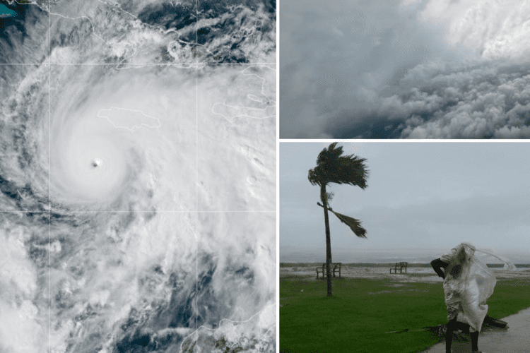
In the pre-dawn hush of a Jamaican fishing village on October 28, 2025, where the sea lapped gently at weathered docks and fishermen mended nets under flickering lanterns, 62-year-old Elias Grant stirred his morning coffee, gazing at the horizon with the quiet wisdom of a man who’d ridden out Gilbert’s wrath in 1988. The air felt wrong—heavy, electric, like the breath before a scream—and as the first gray light pierced the clouds, a low rumble built from the east, swelling into a roar that drowned the waves. Elias’s wife, Maria, clutched their grandson’s hand, whispering prayers in Patois as the wind clawed at their tin roof, ripping palm fronds like paper. By 1 p.m., Hurricane Melissa made landfall near New Hope, just 40 miles south of Montego Bay, as a monstrous Category 5 with 185 mph sustained winds, tying it for the strongest Atlantic hurricane to ever strike the island. But it was a fleeting gust—clocked at 252 mph just above the surface—that would etch Melissa into eternity, verified days later as the fiercest wind ever measured in a hurricane. For Elias, who lost his home and Maria to the storm’s savage surge, this wasn’t a statistic; it was the thief that stole his world in an instant, a reminder that nature’s rage spares no one, leaving only echoes of what was.
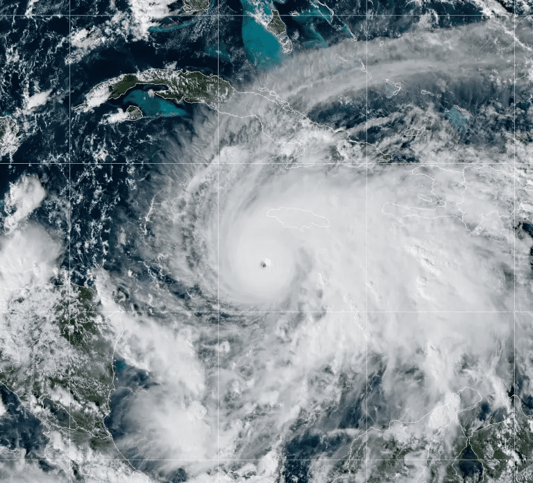
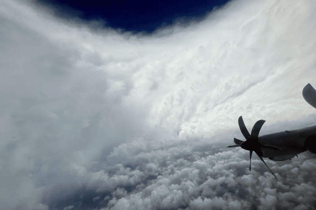
The verification of that unearthly 252 mph reading came not in the storm’s howling chaos, but in the sterile glow of laboratories thousands of miles away, a testament to science’s steady hand amid nature’s frenzy. On October 27, as Melissa bore down on Jamaica with the inexorable grace of a predator, a NOAA WP-3D Orion Hurricane Hunter aircraft—affectionately dubbed “Kermit” for its green fuselage—plunged into the eyewall, its crew of meteorologists and pilots battling turbulence that tossed the plane like a leaf in a gale. Amid the roar, they deployed a salvo of dropsondes, those Pringles-can-sized marvels of engineering that parachute through the storm’s fury, sampling pressure, temperature, humidity, and wind two to four times per second via satellite uplink. One instrument, released at 9:50 a.m. EDT in the south-southeastern eyewall, captured the anomaly seconds before splashing into the Atlantic: a gust of 252 mph (406 km/h, or 219 knots) at a mere 657 feet (200 meters) altitude, shattering the previous record of 248 mph set by Typhoon Megi in the Western Pacific in 2010.
The National Hurricane Center (NHC), poring over the data in real time from their Miami nerve center, flagged it as a “potential record” with cautious optimism, their screens flickering with Melissa’s satellite loops showing a pinhole eye amid a cauldron of convection. To confirm, they turned to the U.S. National Science Foundation’s National Center for Atmospheric Research (NSF NCAR), the cradle of dropsonde technology since its invention in the 1970s. Researchers like Holger Vömel, a veteran atmospheric scientist at NCAR’s Earth Observing Laboratory, ran the telemetry through rigorous post-processing software—algorithms that scrub for glitches, cross-check against physics’ iron laws, and align with hurricane norms. “We scrutinized every data point,” Vömel later shared in a UCAR news release, his voice carrying the quiet thrill of discovery tempered by the storm’s grim toll. “No anomalies, no gaps—the gust tracked perfectly with Melissa’s structure, her warm waters fueling that extreme shear.” By November 19, the verdict landed like a gavel: verified, the strongest hurricane wind ever directly measured by dropsonde, a feat impossible without these intrepid probes in environments too lethal for other tools.
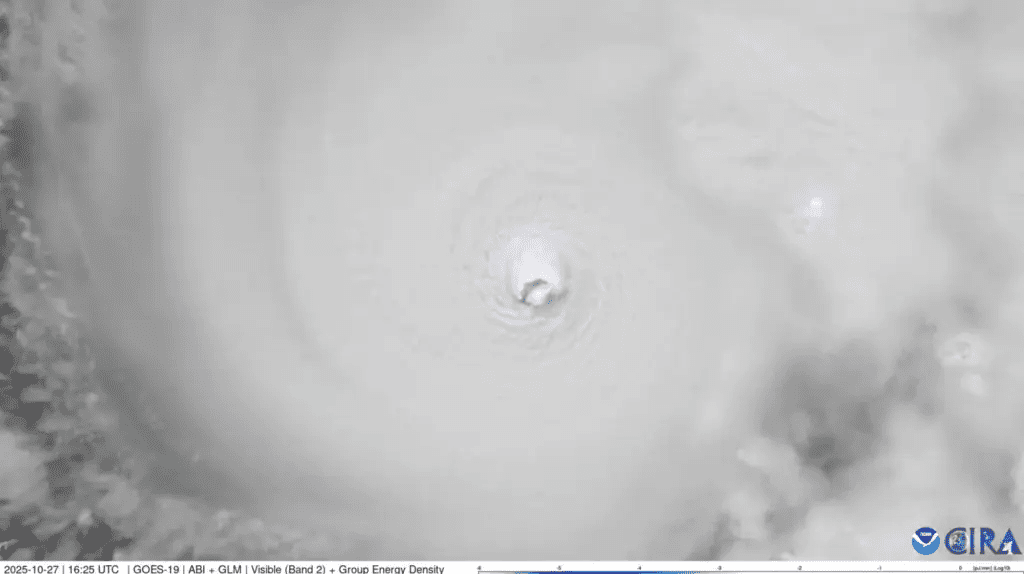
Melissa’s ascent to infamy was no fluke of fate, but a symphony of climate’s cruel crescendo, her rapid intensification a harbinger of storms grown fiercer in a warming world. Forming as Tropical Depression Thirteen on October 23 from a persistent wave off Africa’s coast, she meandered westward at a languid 5 mph—slower than a brisk walk—over ocean heat content rivaling a hot tub, sea surface temperatures hovering 86-88°F (30-31°C), primed by El Niño’s lingering kiss and human-fueled greenhouse gases. By October 25, she doubled her winds from 70 mph to 140 mph in 18 hours, eschewing the eyewall replacement cycles that typically temper giants, sustaining her fury through Jamaica’s rugged spine. Satellite imagery from GOES-16 captured the mesmerizing meso: a 10-mile eye ringed by 100-mile-wide walls of thunderheads, her pressure plunging to 892 millibars—the third-lowest in Atlantic history—tying her landfall intensity with the 1935 Labor Day Hurricane in the Florida Keys.
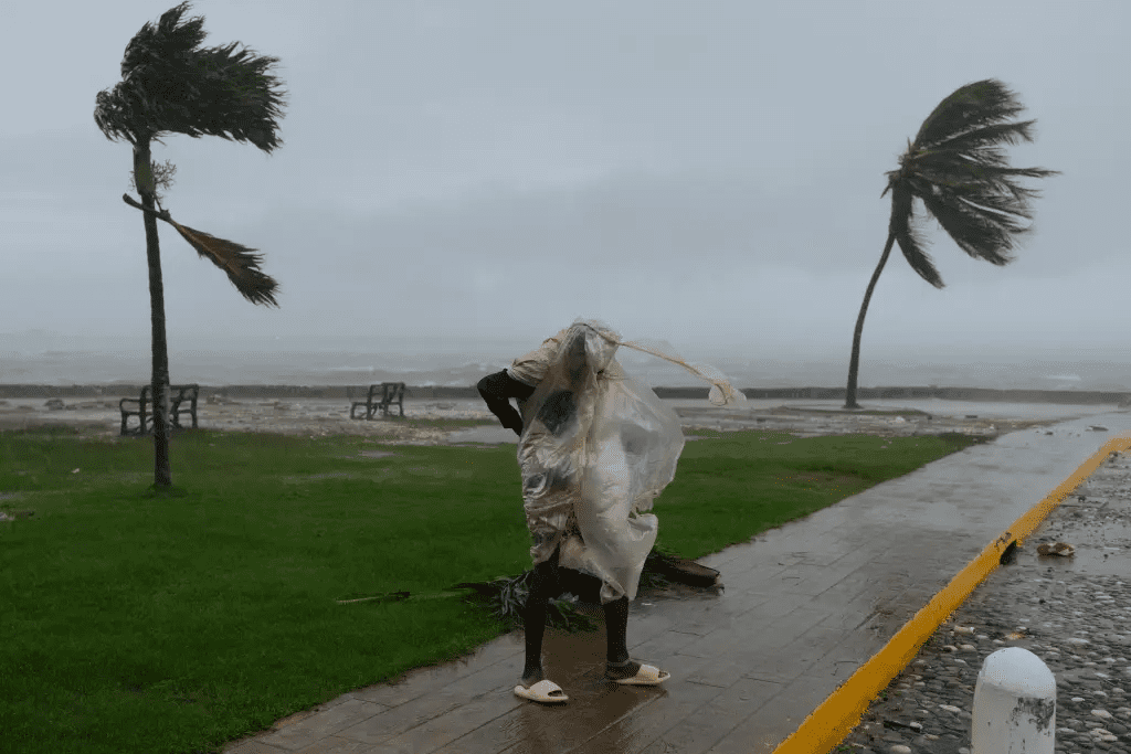
For Jamaica, the island of reggae rhythms and resilient spirits, Melissa was apocalypse in slow motion, her crawl amplifying the deluge to 30 inches in mountainous interiors, where landslides entombed villages like a biblical flood. Landfall at New Hope unleashed hell: Black River’s medical facilities crumbled like sandcastles, Kingston’s trees snapped like matchsticks, Montego Bay’s airport roof peeled away mid-evacuation. Over 5 million Jamaicans—nearly the entire population—felt her wrath, with 76 confirmed deaths by November, search teams still sifting rubble in the Blue Mountains. “It was like the sky fell,” Elias Grant recounted from a Red Cross shelter in Montego Bay, his bandaged arm a souvenir from debris that claimed his wife’s life as their home folded inward. “The wind screamed like a thousand ghosts, and then… silence, broken only by cries.” Across the Caribbean, Melissa’s path carved a scar: Cuba’s eastern provinces battered with 150 mph gusts, Haiti’s fragile tents shredded anew, adding to a death toll that climbed to 150 region-wide, per UN estimates. Economic losses? A staggering $25 billion, with Jamaica’s tourism mecca—Negril’s beaches and Ocho Rios’ falls—left in tatters, hotels shuttered and coral reefs scoured by surge.
The dropsonde’s revelation, captured at 657 feet where winds peak in the boundary layer, underscores Melissa’s monstrosity: a gust 67 mph above her sustained 185 mph, in an eyewall where shear and heat conspired for extremes. NCAR’s Vömel called it “mind-boggling,” a reading that aligns with models showing climate change juicing intensification—two rapid attribution studies pegging Melissa’s warm waters as 500-900 times more likely due to human emissions, boosting her top speeds by 10 mph and damage potential by 50%. “This isn’t just data; it’s a warning,” said Yale Climate Connections’ Jeff Masters, the veteran forecaster whose live blogs during Gilbert made him a legend. “Melissa’s like Gilbert on steroids—slower, stronger, wetter—because our oceans are feverish.” The verification process, a blend of software sleuthing and physics fidelity, echoes past dramas: Hurricane Katrina’s 2005 “193 mph” gust discarded for sensor glitches, ensuring Melissa’s mark stands unassailable.
Yet amid the science’s triumph lies the human heartbeat, the stories that transform numbers into nightmares. In Treasure Beach, where video captured waves crashing like freight trains an hour before landfall, 29-year-old single mother Aisha Campbell huddled with her two toddlers in a cinderblock school turned shelter, the wind’s howl drowning their whimpers. “I held them close, singing Bob Marley to keep the fear at bay, but inside, I was breaking,” she shared in a tearful CNN interview from a Kingston relief camp, her eyes distant as she recalled the roof’s groan and the flood that swept away her market stall. Aisha’s loss—her livelihood, her sense of home—mirrors the island’s collective grief, where 200,000 displaced roam tent cities, schools shuttered, and farmers survey fields of snapped sugarcane like battlefields. In Cuba, where Melissa churned as a Category 4 post-Jamaica, Havana’s colonial facades cracked, 20 dead in mudslides that buried barrios; Haiti’s Cité Soleil slums, already fragile from Matthew in 2016, saw cholera spike amid contaminated wells, aid convoys crawling through debris-choked roads.
Recovery flickers like a candle in gale, with Jamaica’s government marshaling $2 billion in international pledges—U.S. aid via USAID, UN clusters distributing tarps and trauma kits. Elias Grant, now volunteering at a Montego Bay soup kitchen, finds solace in the communal mend: “We Jamaicans, we rise—reggae from the ruins, rum from the wreckage. But Melissa took pieces we can’t rebuild.” Globally, her record stirs urgent calls: the UN’s climate summit in Baku, mere days away, will spotlight her as Exhibit A for emission cuts, her 252 mph gust a siren for resilient infrastructure—from Jamaica’s $500 million seawall plans to Haiti’s solar-powered clinics. NCAR’s dropsondes, evolving with AI for real-time anomaly hunts, promise better warnings, but experts like Masters warn: “Warmer waters mean more Melissas—intensifying 30% faster, lingering longer, hitting harder.”
As November’s chill yields to December’s tentative thaw, Melissa’s legacy lingers not in ledgers or labs, but in the resilient rhythm of lives remade. For Aisha, it’s rebuilding her stall with donor bricks, her toddlers’ laughter a defiant melody. For Elias, it’s planting a mango tree where Maria’s garden stood, roots delving deep against future gales. The 252 mph verification, a feather in science’s cap, serves as elegy and exhortation—a measure of might that humbles humanity, urging us toward stewardship in a world where winds whisper warnings we can no longer ignore. In the Caribbean’s emerald embrace, where storms come and go but spirits endure, Melissa’s roar fades to echo, a heartbreaking hymn to the fragile beauty we fight to preserve.