U.S. Coast Guard Races to Track Russian Intelligence Ship Off Hawaiian Coastline
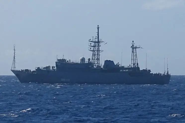
In the quietly shifting blue of the Pacific, just south of Oahu, a gray hull cut through the horizon in late October — a vessel belonging to the Russian Navy, officially designated as the Kareliya (a Vishnya-class intelligence ship), was detected at approximately 15 nautical miles off the coast of Hawaii, triggering a heightening of maritime vigilance by the United States Coast Guard.
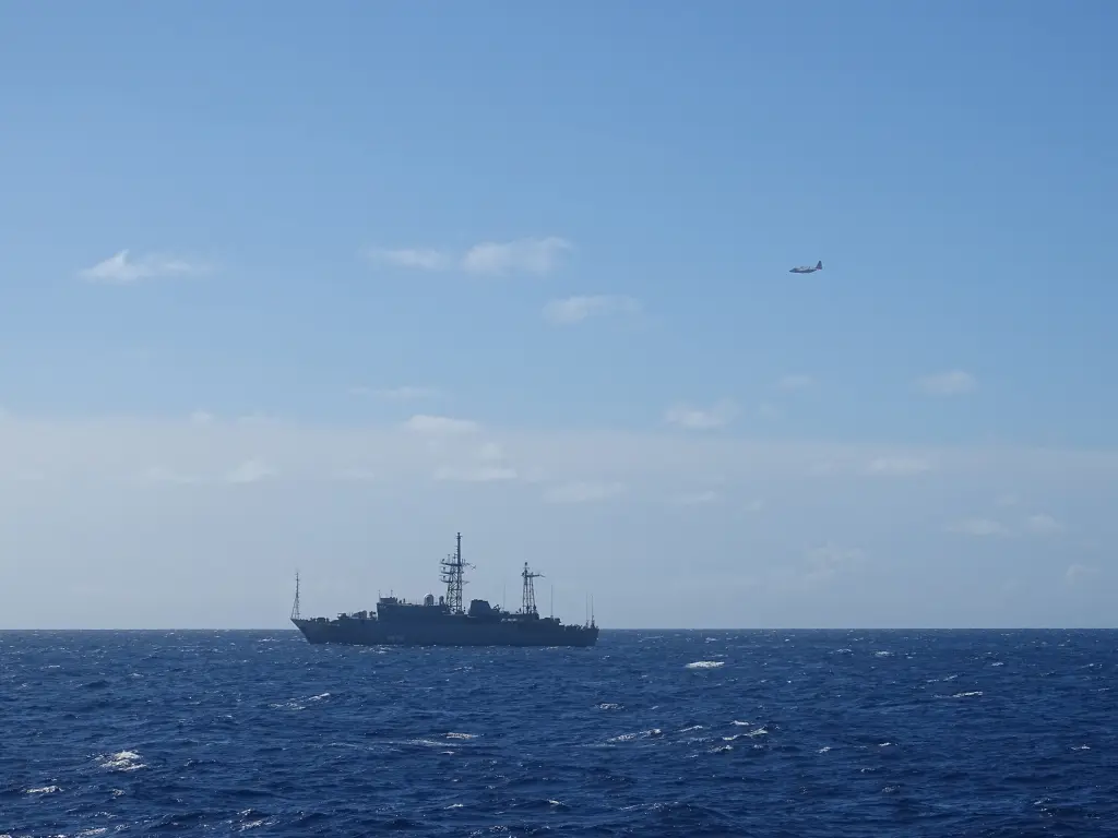
Officials say the Coast Guard deployed an HC-130 Hercules aircraft from Air Station Barbers Point and dispatched the cutter USCGC William Hart (WPC 1134) to fly over and shadow the Russian vessel as it transited through international waters.
The timing could not be more geopolitically sensitive. With global tensions mounting, the mere presence of a foreign intelligence ship so near U.S. territory has raised concerns both about the optics and the implications. At the same time, officials emphasize that under international law — specifically the United Nations Convention on the Law of the Sea (UNCLOS) as interpreted by customary maritime practice — foreign military vessels may operate outside another country’s territorial sea, which generally extends up to 12 nautical miles from the shore.
According to the Coast Guard statement, the Kareliya’s location was first noted on October 29, 2025. Coast Guard crews say they are continuing to monitor the ship as it operates near but outside U.S. territorial waters. The ship’s presence has been described as “routine” in the sense that surveillance vessels have long conducted operations in the Pacific, but the proximity and current global environment make this particular incident stand out.
Capt. Matthew Chong, chief of response for the Coast Guard’s Oceania District, stated: “The U.S. Coast Guard routinely monitors maritime activity around the Hawaiian Islands and throughout the Pacific to ensure the safety and security of U.S. waters. Working in concert with partners and allies, our crews monitor and respond to foreign military vessel activity near our territorial waters to protect our maritime borders and defend our sovereign interests.”
For many Hawaiians and observers of Pacific security, the image of a foreign intelligence-collection ship so near the archipelago’s shores evokes unease. The shoreline may be peaceful, but the ocean lanes are far from neutral. The U.S. First Island Chain and Pacific approaches remain strategic choke points, and any vessel bearing intelligence-gathering capabilities — such as electronic surveillance, signal interception arrays, or ocean-sensor packages — draws careful scrutiny.
In an earlier era, such intelligence ships would monitor naval exercises or submarine transits in the Pacific. In July 2021, for example, the cruiser Varyag led a large Russian Pacific Fleet task force operating near Hawaii, including the Kareliya. The current incident raises a similar question: what mission is this ship on, and what message is its presence sending?
The Coast Guard is not alone in monitoring this: the United States Indo-Pacific Command (USINDOPACOM) and other allied maritime agencies are closely watching surface and subsurface activity in the Western and Central Pacific, particularly in light of China’s expanding naval presence and Russia’s renewed long-range naval deployments. The inter-agency coordination underscores how maritime security near Hawaii is no longer a local affair — it is tied directly to global projection and deterrence.
From a legal standpoint, the presence of the ship outside the 12-nautical-mile zone means the Russian vessel is technically in international waters and therefore its operation is permissible under the law of the sea. But the question isn’t only about legality — it’s about intention, capability, and risk. Intelligence ships are typically designed to gather electronic and signals-intelligence (SIGINT) data, meaning they could monitor communications, naval traffic, satellite links, or even undersea cable movements. That the U.S. is observing it rather than scrambling at the sense of violation is a sign of both readiness and caution.
The Hawaii-based monitoring operation illustrates how geography amplifies strategic importance. The Hawaiian Islands sit thousands of miles from continental U.S. forces yet serve as a critical midpoint between Asia and the mainland. A vessel operating so nearby can gain unique vantage points. Observers note that even if the ship remains in international waters, its proximity to the Hawaiian coastline, nearby bases, satellite ground segments, or undersea communications channels gives it potential access to valuable information.
Nonetheless, U.S. authorities emphasize that no unsafe or unprofessional behavior has been reported from the Russian ship. The statement reflects an effort to temper public alarm while signaling vigilance. “We have not observed any unsafe or unprofessional behavior and we expect that the Russians will operate within the region in accordance with international law,” Pentagon officials said in a similar context when Russian surveillance vessels were noted in the Pacific in recent years.
But the broader message is clear: maritime competition is alive, and the zones beyond the horizon remain contested. For U.S. residents of Oahu and beyond, this episode is a reminder that security isn’t confined to the shoreline but extends into the deep waters — invisible perhaps to the casual beach-goer, but intimately connected to national defense.
The Russian Navy does not yet appear to have publicly commented on this particular deployment. Russian diplomatic channels have remained silent so far. That silence is itself telling — in intelligence work, absence of comment often marks both discretion and the unspoken nature of the mission.
In the coming days, the Coast Guard will continue to patrol and track the vessel, collect navigational, emissions, and radar data, and coordinate with the Navy as needed. Such attention will serve dual purposes: ensuring the vessel remains in compliance with laws and norms, and signaling to Moscow that the U.S. maintains vigilance close to its sovereign sea lanes.
For policymakers, the incident presents questions about how to balance deterrence, freedom of navigation, and diplomatic messaging. If the U.S. reacts too aggressively, it risks escalating tensions; if it reacts too passively, it may appear unprepared. The approach today — watchful but not overtly combative — suggests a calibrated posture that recognizes the complexity of modern naval competition.
For Hawaii’s communities, while there is no immediate cause for panic, the proximity of the surveillance ship invites reflection. Under the clear skies and gentle trade winds, the notion that the waters nearby are part of a complex intelligence and defense matrix may feel distant. Yet for maritime professionals and strategic watchers, this kind of deployment is part of an evolving pattern of near-shore operations, where strategic advantage can be gained quietly and incrementally.
As the ship continues its transit, the question remains: what will the data reveal, and how will the U.S. respond next time an intelligence vessel from abroad skirts its waters? Will the next incident bring more visible countermeasures, or continue to be quietly monitored at a distance? Either way, the Pacific appears increasingly layered with strategic shadows, and the coast of Hawaii is now firmly on the map of that hidden world.